Caves are holes in rocks, The rock in is generally limestone, but how and why do they form and what makes one very different to another
This page describes the geology of caving areas, especially our British caving and to some extent mining regions.
Also some foreign places as well where another form of natural underground passage "lava tubes" are found.
How the geology has been shaped to give us those landscapes and how the geological and physical landscapes shape the types of caves etc. and the
potential for caves in each UK region.
please note that it was originally a presentation I gave at a BCRA workshop using an overhead projector (remember those?) and then a set of
pages I put online elsewhere about 20 years I recently found in a sort out l bring them up to date here as I get time
To read through them in sequence, just scroll down, but to go to a specific section please select a link
At a number of places in these descriptions you will find a number of Geological terms used. I have hyperlinked key words to further
sources of reading that you may find interesting or useful.
If you are not familiar with some of the concepts involved I would recommend these resources for your edification.
Geological timescale
Summary Geological Timescale
In order to fully appreciate the time that it has taken for things to happen, either the creation of the caves or the creation of
the much more ancient rocks that they are in you will need to know something of the Geological timescale. To that end I provide here a summary
geological timescale with the names as commonly used in the UK and the age of the top of each section in
Millions of years old (with the exception of the top of the Pleistocene which is in thousands of years instead)
This has (unfortunately in many ways for us Brits) been revised significantly in the last few years as a
much greater mastery of British and International stratigraphy has allowed international and intercontinental correlations and new type sections
have been agreed. This means that some of the standard British terms for ages of rocks are not now used in the more modern texts.
If you do want the detail, rather than repeat and have to update a constantly shifting set of names
I provide a link to the
Standard British Geological Survey Timescale .
Here you can browse through the various ages and see the latest terminology.
You can also find links to the
Stratigraphical Framework documents if you wish to get information on old and new terms for specific beds of rock
It is my intent to provide a summary of some of the key old and new terms as they specifically relate to UK Cave geology here when I
get some time
Many geologists now support the definition of a new time period at the top pf the geological timescale the
Anthropocene
as defining the age at which the impact of humanity can be seen n the geological record worldwide.
It has yet to be agreed formally and there is still a lot of debate over the use of the term and the age at which it should start
The main aspect of geology that effects a "caving" region is the type of rock that is found there. These can be broadly categorized
into Cave Bearing Rocks & Mined Rocks
Cave bearing rocks are basically soluble in some way, Mined rocks can be almost anything that has a commercial reason for mining it
Carboniferous aged limestone with Crinoid ossicles, Bendricks, Wales UK The red colour is iron staining from other rocks
Rocks that are of caving interest in Britain are mainly limestone as described below, but include some of the rocks that have been
mined. These include a number of Sandstones that have been either quarried for building stone or use in other industrial processes.
Examples of these that are accessible to cavers are the Dinas Silica Mines
South Wales, the Box Stone Mines near Mendip,
and the Alderly edge Copper Mines in Cheshire
and the underground parts of the slate mines of North Wales
Limestone is made of Calcium Carbonate (CaCO3), either in the form of the shells of microscopic and larger animals or
precipitated from sea water directly. Most limestones are laid down in warm tropical/subtropical seas such as the Bahamas and
the Great Barrier reef off the east cost of Australia where large amounts of limestone are being created today, so it's a good
indicator that the areas with caves were once in these sorts of climates, and by looking at these
climates today we can understand things about the limestone which help us find more caves
Limestone is dissolved by slightly acidic water as well as by the normal processes of physical erosion (i.e. the scraping away by
the abrasion of harder minerals such as sand grains when washed
against it). This means that even slowly moving water passing through the rock can enlarge any existing weaknesses and turn them into caves.
However not all limestones are ones that good or large caves are formed in, there is an optimal hardness and structure that
allows good cave formation, for example the Chalk so widespread in the UK and so well known for the cliffs of Dover and East Yorkshire is too
soft and crumbly and allows water to flow through it in many different directions for large caves to be commonly found in it. This does not mean
that no caves are formed in chalk and there are some notable ones on the south Devon coast
There are other rocks that contain caves Dolomite
and Marble
are too types of rocks that are very closely related to Limestone and they are described below.
Dolomite is Calcium Magnesium Carbonate (CaMg(Co3)2) the additional Magnesium makes it a slightly
heavier and harder mineral and one that is less soluble in weak acids,
therefore caves in Dolomite tend to be smaller, and are often "sharper" and less comfortable to crawl across or squeeze through.
Marble is a term that is used for either of these rocks when it has been recrystallized by heat and pressure.
Other evaporate rocks such as gypsum and salt can have caves formed in the same way, but these rocks are very soluble and
you need a much drier climate than the UK for them to be usual at the surface and have caves formed in the same way.
Aspects of Limestone that effect caves
There are many factors that effect the cave that will be formed. The specific nature of the Limestone, the amount of water passing
through, how acid the water is and how much sediment it's carrying, the dip of the rock and whether it's cut through by faults or has been folded.
The following sections go through these in some more detail.
Solubility/Permeability
One of the Key aspects that effects the way caves will be formed in limestone is the solubility of the rock. In fact calcite is not
much more soluble than Quartz in pure water, it requires a chemical reaction to change it into a soluble form. Solubility is therefore the chemical
reaction with the Calcium Carbonate (CaCO3) being dissolved in a number of acids based on dissolved Carbon Dioxide Calcium Carbonate
(CO2). or Humic type acids
which have very complex structures
The Carbon dioxide gets into the cave as dissolved gasses in the water, and then the
resulting acid reacts with the limestone to form bicarbonate which is dissolved into the water and
washed away. There are a number of reactions that take place, but these can be summarized as
The reaction has in fact made calcite more than 5 times more soluble than the original calcite.
Some limestones are very porous and the water can flow easily through these pores. However such
rocks are usually very soft and don't form very good caves as they collapse so easily. As already mentioned above, an example
of this in the UK is the Cretaceous age rock, the Chalk of South and Eastern England which is very porous.
Dip and Strike and jointing in rock
e lack of such porosity is however no limiter to cave formation. The most popular cavernous rock in Britain is the
Carboniferous aged limestone.
This is a poorly porous rock, very hard and crystalline but it has many bedding planes and has been fractured by many joints as you can see
in the picture which allow the water to flow through the rock and therefore the dissolution takes place on the surfaces of these joints as well as
the bedding planes.
The details of how dip and strike effect cave formation will be described below
Limestone that has been turned to Marble by heat or pressure will generally not dissolve as easily
as a softer rock. Small sharp caves in older limestones such as the caves of the Isle of Skye, Scotland, which are in very old Dalradian Limestones
(600 Million Years Old) are examples of this. However it's not right to assume all older or marble derived caves are small
A limestone can also be made harder because of chemical impurities. As described above, a good example of this is caves that are
formed in limestones that have a high proportion of Dolomite, Calcium Magnesium Carbonate (CaMg(Co3)2).
This is often seen where there is a partially dolomitized limestone and you get some beds with more dolomite and some with more calcite.
In these occasions there is often a clear difference with smaller passages in the dolomite and large in the calcite.
In South East Wales there are dolomitic layers in the sequence and the passages in these layers tend to be smaller and sharper, and for the cave
explorer it is quite desireable to "break through" in to a more pure limestone layer where larger passages that are easier to explore can be found.
Thickness and bedding of Limestone
Carboniferous aged limestone of different hardness and thickness of beds Burrington coombe, Mendip UK
The thickness of limestone has a major effect on the type of caves that are formed.
Some limestones are very thin bedded because they were formed in an environment where there was some
interruption in sedimentation whereas some were formed in an environment with a more constant
input of sediment, or there was some form of reworking of the sediment such as
bioturbation
There are series of limestones that contain both thin and thick beds such as the one from Burrington Coombe shown here.
This thin bed of rock is seen across a wide area and shows up as a significant
marker bed
Thin limestones that are interbedded with other rocks such as shales may be totally or partially sealed from having water flow into
them. This will prevent cave formation if there is a lot of the other rock, or if the water has managed to enter the limestone, it can give rise to
a level passage at a water table. It is also not easy for long pitches to be formed where there are thin limestone layers with non-soluable layers
between.
In such areas small "flat" systems are usually developed along the bedding planes are formed. I have personally explored some very
small flat grotty holes in the Yoredale Series
rocks of Dentdale, orth Yorkshire
Depth of Limestone
Caves can form in any limestone, but deep vertical caves will only be formed where there is sufficient depth of limestone for them to
be formed in. In the UK there are different depths of limestones in the different regions with Yorkshire having the greatest vertical depths of rock
and therefore not unsurprisingly the greatest concentration of deep vertical caves. However because caves are not just vertical it is actually
in South Wales where the greatest depth within a UK cave 308m is found in South Wales. It is Ogof Ffynnon Ddu (OFD) in the Swansea Valley.
OFD has caves right through the limestone beds from the topmost in the upper areas of the cave right down to the lower layers just
above the Old Red Sandstone that is below the cave. It is not a steeply vertical cave the depth is because of a relatively gently downward slope over
a long horizontal range. The trip from the Top Entrance to the Ogof Ffynnon Ddu 1 entrance is the deepest cave through trip in the British Isles at
231 m.
Very deep sections of limestone can be found in mountainous regions such as the Pyrenees in Spain and the Vercors area of France
that contains the Gouffre Berger, but the worlds deepest caves are now all situated in Georgia in the region between eastern europe and the near
east of asia
Reefs
Corals on the Great Barrier Reef Australia
Reefs are areas of limestone that
were once algal and/or coral reefs, just like the Great barrier reef today. These tend to be thicker, unbedded areas of limestone that may have
different properties to the limestone around them. The fore reed (ocean side) will tend to be thinner bedded with fragments of corals etc. that have
been broken off and washed down, whereas the back reef (sheltered between reef and coast) will often be very thinly bedded or have layers of
sediment in it depending on whether river input was close or not. They can either be areas that are good for cave development or areas with poor
cave development depending on the surrounding limestone and their physical properties The classic area for reef limestones in the UK is Derbyshire
where the Castleton Reef limestones contain some of the regions best and most visited caves.
Relation to other rocks
Water falling on impervious rocks and coming onto limestone where rapid cave development can be
dominantly vertical Descending on SRT equipment Calf Holes Yorkshire
At places where a thicker layer of limestone is found beneath a layer of non permeable rock (a rock that does not allow water though), entrances
are commonly found because the runoff has been concentrated into one place by the streams instead of seeping in over a wider area.
One of the most
classic examples of this sort of cave development is Kingsdale in Yorkshire where Simpsons', Swinsto & Yordas caves are found where the water
flows off the Yoredale rocks onto the limestone. In all of these caves the water has cut down through the deep layers of limestone below the
Yoredale series very aggressively creating multiple deep potholes within the system and in that way creating the classic SRT through trips that
are enjoyed by so many cavers.
As an aside SRT stands for Single Rope Technique which is when descenders and ascenders are used to go down and up a single rope which is a
lighter and in many ways safer mode ascending and descending than the older Ladder and lifeline technique. The picture shows me using this
technique
Folding
All of the British limestones have been folded and uplifted from where they were formed at the bottom of warm tropical seas.
There are 2 types of folds that are most common. Anticlines (upfolds) and synclines (downfolds)
Upfold or Anticline in rock Downfold or Syncline in rock
The different caving regions have been subjected to different degrees of folding with the South Wales region being formed out of one
large synclinal basin, and Derbyshire being a large anticlinorium (an anticline with smaller folds on the sides of it) they therefore have different
dips and this has a major effect on the caves of each region as will be described in more detail in the regional descriptions below.
Water flows on Dip and Strike and jointing in rock
Folding also gives rise to joining where the relatively brittle limestone is cracked without movement (compare with faulting below).
This is show in the blue limestone layers in the diagrams. Jointing usually occurs in 90 degree grid patterns when viewed from above. These can
easily be seen on limestone pavements which are flat beds of limestone which have been scraped clean by ice and then weathered to the point where
you can see the join patterns easily.
Water will tend to flow either along a horizontal plane (at or below the water table) or will try and descend to a lower level
(above the water table).
The limestones of the Yorkshire Dales are almost horizontally flat, with almost no folding visible in large areas of limestone. Combined with their
thickness this leads to water flowing along the bedding until it can find a way down and therefore a series of horizontal and vertical passages are
formed.
Around the "North Crop" of the South Wales region the limestones have been folded to a moderate extent. This combined with the way
that valleys have been formed that often mean that water has some distance to flow before it can resurge. The result is systems that gently work
their way down a vertical height, without having to form vertical pots.
Carboniferous aged limestone at The Rock of Ages, Burrington, Mendip UK
The resulting long stream passages are of course famous are superb trips, but as you go along it is interesting to look at the
detailed shapes to the passages and relate them to the geology. The OFD stream way whilst generally trending down dip as a vadose canyon showed
evidence where it has taken a path based on the join patterns in many places
In Mendip the rocks are folded to much a steeper angle as can be seen in the picture from Burrington Coombe. Here the water often has
to flow deep below the water table before it can find a way up again. This gives rise to deep sumps and caves with steeply sloping passages
Faulting
Normal (tension) Fault
There are 3 main types of faults and all are seen in caves. The type of fault that occurs when rocks are under tension is called a
Normal fault and that caused when rocks are under compression is called reverse fault.
Reverse (compression) Fault
if you look at the blue layers on these diagrams you can see that on the normal fault there is a downwards step across the fault and
a bed of rock will not repeat whereas with a reverse fault the rock is pushed up and over itself and it is possible for a rock to appear twice once
above another. If the Reverse fault is at a low angle to the rocks that it is in, it is called a Thrust
Faults are lines of fracturing that cut through layers of limestone, just as they cut through any other rock. They may bring a layer
of impervious rock against a layer that allows water through and this may have a major affect on cave development.
If on the normal fault diagram the blue is the limestone and water is flowing along it, and if the grey is an impervious mudstone
then the water will not be able to flow further. if on the reverse fault we consider the green to be an impervious later the same could happen, but
look carefully and on this case you can see that the limestone touches at corners and this could be a situation where water could flow upwards if it
was under enough pressure by coming from a higher level above and to the left (a U bend could be formed)
Cave at the Moine Thrust, Scotland A Reverse fault with significant movement
Even if there has not been sufficient movement to
bring rocks of different types together faults will generally be areas of weakened rock that are exploited by water to form caves. An example of
that is shown here where cave development is occurring along a minor mast of the Moine thrust complex in the Traligill Valley, in Assynt, Scotland.
The steeply sloping section to the left of the picture is one part of the limestone that has been over thrust by the layers now above which
may have come from the same layer, or even a later beneath that on the left depending on how far they have moved. As at this specific location both
sides of the thrust are limestone it's not easy to tell
The third type of fault is a strike-slip fault where the tear
in the rocks involves a predominantly horizontal movement (in relation to the rocks). These may be hard to see in horizontally bedded rocks,
in these type of faults the geologists try to determine which way the rocks have moved.
Strike Slip Fault when viewed from above
Whilst these type of faults may not bring different rocks
together, they can cause a plane of weakness and broken rock which is easier for water to move through and easier to be dissolved because of
greater surface exposed to acidic water and for that reason they can be zones where caves are formed
In South wales there is a pervasive NNW - SSE faulting pattern, and this is reflected in the orientations of the passages in such
caves as Agen Allwedd, Daren Cilau, Craig y Ffynnon and is probably most clearly seen in Ogof Draenen where the fault line that forms the main stream
passage has been such a strong feature that it has captured all of the water and at present there is no cave significant discovery to the West of the
fault line in any area other then the highest parts of the cave. Some of these faults in South Wales have almost no movement from one side to the
other, and some have movements of many meters.
Veins
Copper Mine based on vein, Coniston, UK
Areas where water has been
passing through the rock Fault lines (such as Derbyshire) often have other minerals deposited into them, these are called veins. These minerals
include such things as galena (lead ore), Malachite and Azurite (copper ores) and are often sought after as they are economically valuable.
These are useful to the caver as the mining of these minerals creates interesting passages that can be visited, and these passages often intercept
caves that cannot be seen at the surface.
Veins can be quite thick and there is frequently a combination of minerals which are mirrored on each side of the vein with metal
minerals in certain bands within the overall vein. The thickness of the valued bands will obviously encourage or discourage miners to follow it and
where the valued mineral is something like Gold which was mined at
Dolaucothi Gold Mines it doesn't take much to make it worthwhile
Mined out veins often contain spectacular formations because the metal ores are oxidized, dissolved and then re-precipitated as
secondary minerals such as oxides and carbonates which tend to be spectacular colours such as these in
Coniston Copper Mines , Cumbria, UK.
The bedrock for these mines is not limestone. The common
primary and secondary minerals found in UK caves are described in the Cave Minerals section below
The key factor that influences the cave development and the passage shapes of caves is whether the passage is formed above or below
water. The level of limestone that is filled up with water is known as the Water Table. This is mostly influenced by the permeability of
the rock and the shape of the land above and in some cases below the caves (although level of rainfall and layers of impervious rock can also have
an effect)
Water Table
Where water goes into the ground it will try and
descend as fast as possible. To do this it makes use of the joints and faults described above and if the bedding is sloping it will use this as well.
Once it reaches an impervious layer it will not be able to descend as fast and it will run along that layer until it reaches a surface outcropping
where it will form a spring.
This is the classic model and is a simple model that only really applies in very straightforward valleys. What happens in many places
is that the water table influences flow in other ways. The Water can flow horizontally along strike in a section of rock that is filled with water
towards the lowest point where the water can escape. This can be some distance away and examples of long main river passages that run for many miles
are known.
The escape point can be in a different valley all together such as in Ogof Draenen South Wales where the risings (springs) are 6
miles south of
the entrance. The hydrology of this cave is very interesting because it shows that the water table was once much higher and flowed to a northern
valley whereas it now flows a much further distance to a southern valley. This is considered to be a case of water capture when the southern valley
was deepened (probably in the Ice Age) and the sudden change from northerly flow to southerly flow can be seen in the cave with a dramatic change in
roof line at the capture point at the junction of main stream passage and Gilwern passage.
Understanding these aspects is important in discovering caves because in this case a major passage that was considered an inlet was
suddenly recognized as an outlet passage which had much more chance of remaining as a large passage. This spurred exploration in that part of the
cave and subsequently many more kilometers of passages were found
Perched Water Table
As described above water will flow down until it
hit's the water table or an impervious layer. If there is an impervious layer of some sort that is not widespread through the rock then a feature
called a Perched Water Table can be formed. This is a part of the rock where the water table is above an otherwise bottom position within the strata.
it can be just above the impervious layer as shown or if the input is sufficient it can be higher again.
Hill / valley shapes
Water tables usually mimic land surface
to some extent, examples will be valley sides where the water table can run along the side of the valley and if there is impervious rock at the
bottom of the valley you will get springs and a river running at the bottom
Water will flow out of the rock if the ground is
very steep which will mean that the shape of the water table will be very steep as well.
Steep sided valleys such as those created by glaciation may not give enough outcrop of limestone, and the angle of dip may not be
right for it to
move a long way underground, and therefore for long caves to form, but may have a steep water table within them and may have deep caves in them.
Examples of such caves are to be found in Kingsdale, Yorkshire as described on the previous page. Here there are a series of cave entrances right at
the point where the overlying Yoredale series rocks finish and the water runs onto the massive limestone beds. The caves are steep as they rapidly
move water down to the valley floor level where the water table is situated right at the point of the Kingsdale master cave
Sediments in water
The gravel and sand that has been picked up by rivers as they flow are a major factor in eroding limestone that is often forgotten
against the more unusual water soluble properties. Simple abrasion accounts for a variable amount of the erosion the amount will depend on the
relative solubility and acidity of the water vs the sediment content and water flow. Studies have indicated that abrasion is not linear with water
speed, but a more complex model including water speed, sediment type and sediment grain size is needed as sediment can promote erosion at low supply
rates by providing the means for abrasion, but it in fact inhibits erosion at high supply rates by burying underlying bedrock beneath more or less
transient deposits. Maximum erosion rates occur at a critical level of coarse-grained sediment supply where the bedrock is only partially exposed.
Fine-grained sediments provide poor abrasive tools for lowering bedrock river beds because they tend to travel in suspension
As mentioned above, where sediment is deposited on the floor of a cave it may protect the floor of the cave from erosion. This in the
cave environment where acid erosion can also take place this gives rise to a mode of cave formation called paragenesis as will be described
below
Types of water
Not strictly topography, but influenced by it is the concept of water mixing.
Caves are now also known to be initiated at inception horizons that occur at the water table, or at a layer of mixed water
types such as sea and freshwater. This is because the mixing of chemistries can give a more aggressive erosional capability
Passages that are formed below the water table
will have the capability of eroding the limestones on all sides. They can produce what is know as a Phreatic Tube which is round to
elliptical in shape. Phreatic tubes can form either along the horizontal strike or they can be down dip and back up again such as in the Mendip
caves where phreatic loops form the sumps in places like Wookey Hole
Shape of Modified Phreatic Tube
In practice phreatic passages tend to be influenced by bedding which is a plane of weakness which water can erode, and therefore a
modified version of the ellipse with extensions along the bedding is found. The modification does not need to be horizontal as show in this diagram,
If the bedding is on an angle
then the modification will be along the same angle. If the bedding is not a significant feature but another feature such as a fault plane is more
significant then the extension of the phreatic passage will be along that plane of weakness
Vadose Canyon
Passages that are formed above the water table
are called Vadose passages. The pure form of a vadose passage is one where the floor of the passage is being eroded by an active river running in the
passage. As the river meanders it will generally create a deep narrow passage which is called a vadose canyon
It is quite normal for a phreatic passage to form and then become a vadose passage. This is either because the whole regional water
table has dropped, or more frequently the passage was stated as a small phreatic passage, but as water created larger passages it became possible for
water to move downwards sooner
Whatever the reason the resulting passage shapes are often quite distinctive. If the Phreatic passage had formed to a sufficiently
large size then a passage shape known as a keyhole will form as show in the picture to the right
Phreatic passage modified by Vadose Canyon aka Keyhole passage
If however the phreatic passage was only small before vadose development took over it will appear as just a rounded roof, or in some
cases a small snaking feature on an otherwise flat roof. These are inception passages and may be a matter of a few inches or up to a meter before
some larger form of erosion took hold and developed the passage in some other way. Such roof tubes can often be seen in the roofs of chambers and from
these the direction and nature of original water flow can be determined which can be an extremely important aspect of determining the overall cave
development. There are many excellent examples of this in the entrance passages and the general area of Big Chamber near the Entrance in Ogof
Fynnon Ddu in South Wales
Vertical passages
One of the most sought after features in cave exploration is a pitch or vertical shaft. These can be formed in either the vadose or
the phreatic zone, and can in fact be formed by water moving upwards or downwards when they are in the latter Phreatic zone.
In the vadose zone the mode of formation is straightforward as they can only form from the top down. Here the normal processes of
erosion take place with sand and gravel in the water having a significant effect, with the impact of water and sediments clearly being an erosional
factor
Formed from the Bottom Up
Paragenetic passage with impervious sedimentary floor and showing notch development
Another mode of cave passage formation was identified in the late 1960's and is becoming increasingly widely recognized. This is
called Paragenesis and it can only take place in the phreatic zone because the mode of formation is for the floor of the passage to get covered with a
layer of sediment which stops it being eroded and then the cave to develop upwards from that impervious layer.
For this to happen there must be enough water flow for acidic waters to erode the roof or walls, but not so much water flow that the
protective sediment layer is removed. If the layer of sediment stays intact this can lead to very large canyons that look at first the same as vadose
canyons, but with very close inspection the migration of any curves in the passage wall will be upwards instead of downwards.
Another feature of paragenetic passages are notching. Notching will occur where the water is flowing in such a way that sideways
weaknesses are exploited, as well as or rather than the roof of the passage or maybe of the passage was not filled with water.
A passage can have one or more
sections above the floor that are widened giving shelves of rock between the notches. One of the best examples of notching in the UK is to be found
in Megadrive passage in Ogof Draenen.
Collapse passages
Collapse formed or modified passage
Where a passage is in rocks that do
not have significant inherent strength, such as a thin bedded rock where there are softer muddier layers between the harder pure lime layers, the
roof of any passage that is formed will be weak and may collapse. If the material that is on
the floor continues to be eroded, this can occur in a repeated fashion so that the passage becomes larger and squared off rather than the rounded
features described above These passages become very squared off in some cases such that they almost look man made.
The Brickyard a Collapse formed Passage, OFD II, South Wales
The upper part of Ogof Ffynnon Ddu has some excellent examples of collapse formed passages where the floor is so covered with
boulders that it was likened to walking across a rubble of loose bricks and hence the name "The Brickyard" was given to the passage
Another good example of this is the Ogof Draenen Main passage at the point it is entered. If you take the old route down this main
passage the floor is literally strewn with boulders and the walls are straight and vertical. In some places it is possible to see a boulder on the
floor that can be visibly matched to a section of roof. Such floors are usually very unstable when freshly found and can be dangerous to walk on. The
first significant accident in Ogof Draenen was when a caver was standing on what was obviously a weak boulder which snapped beneath him and he fell
and broke a finger
Boulder Chokes
Boulder Choke formed by collapse Caver coming through small gap in boulder choke OFD II, South Wales
If this cycle of collapse continues it can lead to a catastrophic failure where the passage becomes filled with boulders
(this can also happen in a vertical shaft).
The ultimate state for a boulder choked cave is of course one that is filled back in again, but in fact most boulder chokes have
gaps and spaces between the rocks which cavers are able to work their way through very carefully (and often with a lot of digging and scaffolding)
Shake and Swallow holes
Shake Holes development above collapsed cave
If collapse has occurred close to the surface then an entrance shaft directly into the cave can be created, but if there is some
other sediment above the limestone then two other very common Karst features can be created.
The picture on the left shows a shake hole which is a simple collapse of the surface into a void underneath where the surface
layers can no longer span in a self supporting manner. These tend to be round or oval in shape and there may be lines of them where a series of
collapses have occurred indicating a cave has been developed along a line often in relationship to a fault structure.
The capping does not have to be a hard rock, even a layer of compacted soil can form a bridge across a cave for some time and the surface can then
suddenly collapse. it is worth noting that the formation of a shake or swallow hole does it need to be a natural event or surface as can be seen
where roads etc. collapse where water has washed away the subsurface following a leaning water main etc.
Shake Holes, Cwm Cadlan, South Wales Swallow Holes, Cwm Cadlan, South Wales
The one on the right shows one where there is a water flow from the left, back and right into the depression which is draining into
the limestone below (slowly in this case because fine peat particles have blocked many of the ways that water can move downwards).
This turns the shake hole into a form of swallow hole. The key feature here is that the water is going underground into a cave and not over a lip
back to flow onto the surface (other than at times of flood where the cave passage cannot take the volume of water
Many cave entrances have been found in the sides or at the bottom of shake and swallow holes, but whether there is a significant
cave developed from there depends on many of the other factors described on this page
An extreme form of this type of surface feature that may be formed by collapse, or by a more large scale regional structure such as
a syncline is called a Doline, in this case multiple caves may take the water out from an area via underground caves and it may appear again may
miles away
Scalloping
Scallops Wretched Rabbit, Yorkshire, UK
A key feature that is common in water eroded passaged that is very useful to cave exploration is scalloping.
It is an erosional feature that occurs in soluble rocks such as limestone.
These are small to large
depressions in the side, floor or event roof of the cave (if it has been created under fully phreatic conditions).
Scallop formation in caves showing flow direction and the formation of steep and shaallow edges
The scallops are formed by the flow
of the eroding water and they have a steep side and a more gentle side. The steep side is formed by an eddy current in the flow regime and therefore
gives the upstream direction of the water as show in this diagram
Scallops as a flow speed indicator
They have a second useful feature in that the eddy currents that cause the steeper side are related to water flow rates.
The faster the water flow the tighter the eddy's and therefore the smaller the scallops. There are complex formulas to try to determine what the
flow rate was, but that detail is beyond the scope of this simple summary.
This diagram gives a simple visual representation of this effect
To describe cave deposits and formations some understanding of the terminology
is needed.
Deposits are primarily anything that has been brought into the cave since it formed; mud, sand,
stalactites and stalagmites are all cave deposits.
Some deposits such as boulders and fragments of shale etc. lie where they fell and are known as autochthonous, others have been moved
to their current location and are known as allocthonous
The shaped deposits that are found in caves such as stalactites, stalagmites, columns, curtains and helicities are given the name
formations.
Similar shaped formations are normally created by similar processes regardless of the materials involved; e.g.. both mud and calcite
stalactites are formed by dripping water.
The term speleothem is reserved for formations that have been laid down in a cave from water and are
typically crystalline formations with banding only. Mud formations are not usually included in the term speleothems: meaning a calcite stalactite
is a speleothem, but a mud stalactite is not.
There are many terms for speleothems, some are different in different parts of the world and some are subdivisions of more common
type. In the sections below some of the more common terms are described. If you want to know more, good places to start are the
Wikipedia Speleothems Page
and the Virtual Cave Solution Caves Page
Types of formations and how they form
Calcite speleothems outnumber those of other minerals by a very large amount.
The main reason that we have calcite speleothems is that the reaction that dissolved the limestone has become reversed. This occurs
because the cave environment has a lower level of CO2 than that in the rock and with the extra oxygen the formula can be reversed and the
can CaCO3can come out of the carbonate solution.
This is as follows
Ca(HCO3)2(aq)
becomes
Ca2+ + 2HCO3-
becomes
CaCO3 + CO2 + H2O
The reactions for other carbonate minerals are similar and this can include minerals that form even when they were not dissolved
from a single source mineral. In other words copper and carbonate dissolved from Chalcopyrite and limestone can become a copper carbonate rather than
a calcium carbonate when they are deposited together. This can give some incredible colours as will be described in the minerals section below
Stalactites - C for Ceiling
Straw Stalactite Close up Peak Cavern, Derbyshire
Stalactites are formations which hang from passage roofs, wall projections and undercuts. They form many of the most spectacular
formations in all caves.
There are 2 types of stalactites, Straw stalactites are relatively self explanatory. They are hollow tubes typically of
calcite, about 5mm across and up to many meters in length. Straws form by the deposition of crystals around the edge of a drop of water and it is the
maximum possible size for a drop of water that gives them their regular size. Some Straws are very pure calcite, colourless and transparent, but most
have some form of impurities in them which make them translucent or opaque. Overall straws are normally white, but there are coloured ones in various
caves
Straw Stalactites Ogof Craig a Fynnon
Large numbers of Straw stalactites can be incredibly impressive such as the ones in Ogof Craig a Fynnon
They occur when the speed of water being delivered into the straw is enough for it to grow, but not too fast that the water is just washing the
dissolved calcite away. In fact they will also not form when the incoming water is moving too slowly as, in that condition the central canal blocks
up with crystals, and the water flows down the outside and create a massive stalactite as described below.
Straw Stalactite with external growth, Travertine Passage, Ogof Craig a Fynnon
Straw stalactites are interlocking crystals which can be seen in close up macro pictures of
the ends of them.
Some straws, of which there are good examples in Travertine Passage Ogof Craig a Fynnon (picture on the left), become blocked and
the water percolates through the sides of the straw, depositing material on the outside, either as fine crystals or more massive layers.
Massive Stalactites, Ogof Craig a Fynnon
Massive stalactites are not always as large as the name might imply, such as the ones to the right which are only about a
foot in length, but they can give some impressive displays. They may be formed by deposition on the exterior of a straw type deposit, but they also
form where water runs over an edge and flowstone develops into pendant formations.
Massive stalactites are often banded inside with growth layers where the amount of deposition has changed from season to season. In
some places
these layers act almost like tree rings with significant interruptions being visible in drought years. This gives an ability to correlate
environmental information from cave to cave and is now an expending field of interest as we try and understand more of how climates change.
Massive Stalactites, Ogof Craig a Fynnon. NB! This tiny picture does not do it justice.
It is huge"
Where water flows out into a large chamber or passage and into an environment with less CO2 you tend to get a lot of
stalactites. The Hall of the Mountain King in Ogof Craig a Fynnon is a good example of this.
Stalagmites - G for ground
Stalagmites form on the passage floors and upright block and boulder surfaces, such as these in Ogof Fynnon Ddu, South Wales and Shatter Cave.
Mendip
Massive Stalagmites, Shatter Cave, Mendip
They are often, but not always, formed below stalactites, indeed in some cases it can be hard to see where the corresponding
stalactite is or the water that is forming the stalagmite is coming from. They are normally broader than their associated stalactite, but not always
so as you can tell from the picture from Coventosa in Matienzo, Spain (below). They can be up to many meters (even 10's of meters) high, and are in
the main formed from massively crystalline calcite.
Just like stalactites they are often layered and can be used for understanding palaeo-environments and for dating purposes.
The rate of growth and the size of the stalagmite will depend on the amount of carbonate saturated water arriving at the floor of
the cave and how it got there. A drip point can move as the stalactites above grow, or the water may be moved around by drafts in the cave
It can be effected by things such as the ability of air to evaporate the water and the shape of the ground that it is being deposited on.
Stalagmites, Ogof Fynnon Ddu
Some small stalagmites form what are called Poached Eggs or Fried Eggs where the central
portion looks darker (and often yellowed) compared to the outer edges. This is due to different crystal shapes.
If the stalagmite is formed over boulders etc it can take on a much larger shape as in this formation in Ogof Ffynnon Ddu which is kown as the
Wedding Cake
Columns
Columns are formations that reach from floor to
ceiling, they are normally formed when a stalactite and stalagmite reach each other and coalesce.
Any stalactite and Stalagmite pair that are above and below each other can become a column and there are many examples where there
is very little gap between the two
Columns are often an even thickness along their length with some thickening at the top and bottom. unless they are recently joined
such as the ones to the left above in Shatter Cave, Mendip which are clearly a stalactite and stalagmite in the recent past, and a clear comparison
to the one from Coventosa, Matienzo, Spain to the right which has clearly been joined for a more substantial time.
In some places it is postulated that columns have been formed in situations where there has been artificially high carbonate input
because of lime kilns on the surface above the cave. The famous Columns in Ogof Fynnon Ddu are said be some to be formed for this reason,
although I have yet to see definitive evidence
Flowstone
Flowstone is formed when layers of minerals are deposited from water slowly flowing down cave walls, across a roof or along the
passage floor.
It is often rippled and coloured by mud and iron and is sometimes built into large 'bosses', which if they are over an edge will have
stalactites dripping from them.
In the picture from Shatter cave above the area to the right of the large Stalagmite can be considered to be flowstone
Curtains are formed where water runs down a sloping roof or ledge and deposits a line of crystals. These are then developed in a
downwards direction, often with bands of colour which are formed by the amount of any impurities varying from time to time. Some of the banding can
be very pronounced and result in these formations being likened to slices of bacon
The typical curved and folded
shape of curtain formations is often attributed to the curving path taken by the original water finding a route down the rock just as droplets take
an erratic path when moving down a window.
However as many curtain formations have an increase in folding as they lengthen this seems to be unlikely as a complete answer. It
may be that the out edges dry more or something to do with the way crystals grow, but to date I have not read a totally satisfactory answer for this
phenomenon
Detail of the edge of a curtain formation, Shatter Cave, Mendip
If a specific drip point wins out then a stalactite may form at that point of the curtain
Curtains are typically only a few mm thick and when clean and close to white in colour light can be easily shone through them.
In some places whole walls can be covered in them such as this cave in Austrailia
Massive sheets of Curtain formations, Jenolan Caves, Australia
Helictites & Heligmites
incredible helictitic formation Chillagoe Australia
helictites are unusually shaped formations which grow from the passage walls or roof and heligmites are those which grow from the
passage floor. Helictites have fine feeder channels for the water just like straw stalactites, but this is generally much finer such that there is
not a water droplet, but the shape of the growth is more influenced by crystal directions which means they can develop in strange directions.
Straws and Helictites, Ogof Ffynnon Ddu, Wales, UK
Helictites can develop into straws and more massive stalactites, and vice verse as the amount of water feeding the stalactite
changes.
Anthodites
Anthodites are radiating groups of crystals or needles which unlike helictites are radiating out from a central base. These may occur
at the end of a straw, or directly radiating from a cave wall. They are usually aragonite, but Anthodites made from gypsum are known. Anthodite
crystals are quite small 1mm -10mm which gives the formations a feathery appearance similar to the anthers of a flower which is where the name comes
from.
Some excellent examples that I had the pleasure of studying are to be found in Urchin Oxbow and surrounding areas in Ogof Daren Cilau,
South Wales. These were the first Aragonite formations to be reported from a Welsh cave, and since their discovery and description Aragonite has
become more widely recognized in many other caves in the area.
Splash Formations
Where lime rich waters abound there are the possibilities for splash formations, These form around the outside of waterfalls and
splash pools and are often characterized by many small bulbous formations.
Excellent examples of these can be seen in Gilwern Passage in Ogof Draenen. Part way up the passage there is a water inlet from above
and the flowstone around the pool is covered in splash deposits
Needles & Crystals
Some minerals such as gypsum grow a single or twinned crystals which can develop into very large crystals. This is possible because
these minerals are soluble at normal temperatures and there is a steady flow of the mineral in a soluble form to add to the crystal. Gypsum has an
unusual growth form compared to most speleothems as it grows from the bottom of the crystal (i.e. that still in the mud or attached to a cave wall)
rather than on the outer surfaces or edges as is normal. What this means is that Gypsum crystals can push things away from the mud or wall surface
and it is not unusual to find patches of dried mud suspended on "legs" of crystals
In previous sections we explored the aspects of geology that give us the varied types of cave that we find in the British Isles.
Often when we venture underground into these caves we pass strange marks on the cave walls. Many of these are fossils, a wide variety of which are
found in the Limestones that we're caving in.
Fossils are the remains of dead animals or plants or the tracks and traces caused by such. They are usually animals with hard outer
shells rather than soft creatures such as jellyfish, and also vertebrates such as fish, but there are exceptions as you will read below.
The chance of finding specific types of fossils depends on the type and age of the limestone. For example the Metamorphosed and very
early limestones of the parts of Scotland like the Isle of Skye are not going to be as richly fossiliferous as the Carboniferous Limestone that
we find in most of the rest of the UK caving regions, and even that varies with reef areas such as are found in Derbyshire being much richer than
the shelf carbonates found in parts of Wales and Yorkshire.
Metamorphism for the name geologists is the process of changing one rock into another by heat and pressure. This normally includes
recrystallizing anything that is there into other minerals and in that process the original structures are often destroyed to such an extent that it
is hard to recognize that they were there of the limestone will no-longer break at the line of weakness that is the surface of the shell wall and
therefore they are hard to extract and identify
Identifying Fossils in Caves
It is often difficult to make an exact identification of the fossils present in caves, as all that we see are cross sections where the
fossils are cut through by the cave passage, sometimes at odd angles. What I hope to give here is an insight into the various main types of
fossils and the habits and forms of the living creatures that these fossils once were. It is often difficult to make an exact identification of
the fossils present in caves as all that we see are cross sections where the fossils are cut through by the cave passage, sometimes at odd angles.
The classic sectional shapes of fossils will be described below and illustrated which should aid in their identification
The types of fossils
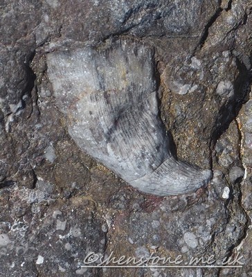
Brachiopods
Some of the most common fossils seen in cave walls are crescent shapes of white calcite showing up in the darker limestone.
These are usually the remains of a group of shells called Brachiopods. Two shelled creatures that spent most of their lives resting on the sea floor,
supported by spines, or holding themselves down with a small fleshy foot called a pedicle.
This pedicle stuck out of the shell through a small hole called a foramen.
Brachiopods are marine, shelled invertebrates that look superficially very much like mussels (see bivalves below).
They are actually quite different in their anatomy, and they are not closely related at all.
They have two shells (valves) of calcium carbonate or combination of calcium phosphate and chitinous organic substance
The two shells of brachiopods are of unequal size (inequalvalved). The valve that has the attachment for the pedicle called the
pedicle valve and is usually the lower and somewhat larger valve. The other valve is called the brachial valve and holds the feeding
tentacles, the lophophore or brachia. The brachidium is a long ribbon or loop-shaped calcified support for the lophophore which is
attached to this shell.
Productid brachiopods
Sometimes the brachiopods are seen with both shells in place and the right way up, and other times they are seen
broken up and washed into layers where there are many broken and / or stacked shells. These are called Life position and Death
Assemblage respectively.
Brachiopods are found in rocks of all Phanerozoic ages because as a group they have existed from the very beginning of the Cambrian
radiation to the present day. However it is fair to sat that their peak time was in the Paleozoic with a small resurgence in the Jurassic where
rhynconellids are quite common. The Brachiopods are now relatively insignificant. Most surviving brachiopods are mostly found in very cold parts of
the Pacific Ocean, either in polar regions or at great depths. There are about seventy living genera and about 300 living species.
Spiriferid brachiopod
Some of the most common brachiopods in the Carboniferous Limestone are the Productids (Example from near County Pot,
Yorkshire left) which are strophomenids. Occasionally, and particularly common in Derbyshire. Very large
specimens of the genus Gigantoproductus can be seen in roof in Carlswalk Cavern, Stony Middleton, Derbyshire. I have seen these
misidentified on a number of caving websites as Oysters which are actually bivalves. They can reach up to 30cm across and are seen as sharp
edged usually white curves in the dark limestone. The life position of the productid brachiopods is with the curved shell cupped upwards and
a second more flattened shell above with the animal living in the space between, and the whole animal held in life position by a multitude of
spines rather than the animal being held down by it's fleshy foot as described above.
Another common brachiopod seen in Carboniferous Limestone are the Spiriferids ( example from Burrington Coombe, Mendip right).
These were actually more dominant in the previous Devonian period, but still very common in the Lower
Carboniferous which is the age of our best caving limestone in Britain
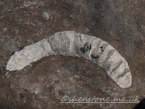
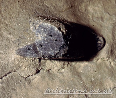
Crinoids
Another fossil that is at least as common in limestone as the brachiopods
is the Crinoid or "sea lily". These fossils often go unnoticed because they are usually fragmented into unspectacular pieces. This is a shame
as the complete animal is quite spectacular.
Although the creature resembles a plant, even to its "roots", it is however an animal (an echinoderm or relative of the sea urchins
and having the same five sided symmetry) which feeds by filtering its food from the water. The circular
fragments that we usually find, once again often in layers, are from the stem or arms of the animal
and are called ossicles. The stem leads from a hold fast attached to the ground (or possibly a
floating object such as a log) or in sediments up to a cup shaped body (calyx). Some layers of
limestone are made up almost entirely of Crinoid ossicles.
Crinoids are known from Cambrian aged rocks right until the present day, but as with the Brachiopods above their times of largest
diversity both in numbers and in species diversity were the Upper Palaeozoic and again in the Jurassic where the five pointed star shaped
Pentacrinites is common
Some limestones in Derbyshire and the Dentdale area of Yorkshire are wonderfully dark grey with white crinoids.
These are wonderful when cut and polished
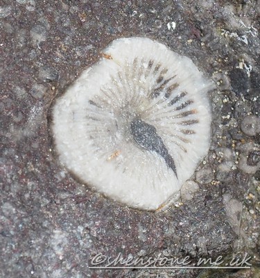
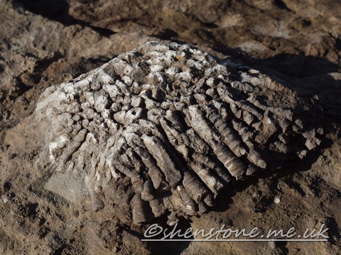
Corals
A third group of fossils often seen in cave walls are the Corals. These are the predecessors of the animals which form the Great
and the reefs in the Bahamas.
Corals are Anthozoa which are Cnidarians (Coelenterata in some older books), a group that includes jellyfish and other polyp type
creatures. Cnidaria are the simplest animals, and do not even possess organs, all they have is a stomach and a mouth which is surrounded by
tentacles
Transverse sectioned coral as useful for dating in Carboniferous aged Limestone, Merthyr Mawr, Wales UK
One of the main features of corals that makes them of interest to cavers is their ability to lay down huge volumes of limestone.
A feature that makes them of interest to geologists is that their internal structure (which we often see in section in cave walls) allows them to
be identified and that is very useful for determining the detailed age of the rocks. In fact many of the layers of the Carboniferous aged
limestone are named in biochronological zones by the name of the most common corals that occur in those layers
There are two key groups of corals that are found in Carboniferous Limestone, the Tabulate corals and the Rugose corals
The Tabulate corals are all colonial and grow upwards as a colony secreting a new floor or tabula every so often for the
active polyp to sit on.
Tabulate Coral colony in Carboniferous aged limestone, Ogmore, Wales UK,
it is noteworthy that this colony is upside down which means that
it has been broken off and moved, this is what is called a death assemblage
These type of corals were most common in pre-Carboniferous times and good examples have been collected from Wren’s Nest near
Dudley in the English West Midlands which is the remains of a Silurian coral reef system. The most common species that are seen are Halysites
which in plan view resembles a set of chains as the polyps grew beside each other in rows of elliptical tubes, Favosites which has closely
packed hexagonal corralites (where the polyps live). Michelinia is another similar coral often seen in carboniferous aged limestone and
Syringopora which is a tubular branching form that where the tubes are round in cross section
The Rugose Corals (referring to their wrinkled appearance) are also known as "horn corals" because the solitary forms look like
animal horns
Rugose coral in Carboniferous aged Limestone, Merthyr Mawr, Wales UK
Common solitary rugose corals include Zaphrentis a small horn shaped form, Caninia a large (up to 60cm / 2 foot)
curved form and Dibunophylum a medium sized solitary form
Caninia coral sectioned in Carboniferous aged Limestone, Ogmore, Wales UK
The limestones of Derbyshire especially are made up in many areas of reef knolls built up from algae and from the skeletons of these
corals, but they can be seen in other caving areas as well, one particularly spectacular example being in the lower entrance to Dan-yr-Ogof, just
beyond the climb to the cavers gate. About 20m further on there is a band of coral about a meter thick that extends for about 15m along the wall
of the cave.
Gastropods
Some rarer, but still occasionally seen fossils are the Gastropods.
Although Gastropods that are cut through so you can see a clear spiral seem clearly identifiable,
this is not always the case, as they can be confused with the Goniatites described below. Both
have representatives that spiraled in the same way, and it is only the presence of chambers in
the shell of the goniatites that enables then to be distinguished.
The gastropod's shell however is not chambered and their soft parts occupy the whole shell. Some
were grazers living on algae and other plant material whilst others active hunters of other
marine creatures (well as active as a snail can get).
Goniatites
Even more rarely identified are the Goniatites.
Goniatites are related to modern Nautilus and squids, and also to the extinct ammonites, they have a shell made up of
chambers with the animal living in the latest and largest, or "body" chamber. They were active swimmers and hunters, using the empty chambers for
buoyancy.
Like the Gastropods, those that are cut through so you can see the spiral have a chance of being
clearly identifiable, but also like them, this is not always the case. Both have representatives that spiraled in the same way, and it is only
the presence of chambers in the shell of the goniatites that enables then to be distinguished. However the thin walls of the chambers are not
always well preserves and there's one in the right hand wall of the passage as you start up Salubrious Passage that I have always been unsure
of.
Bivalves
Bivalves are the most common group of 2 shelled seashells alive today. Thay are things such as mussels, clams and oysters.
Most of them, such as mussels and clams have the same shape (but mirror imaged) shalls both side, but others have differently
shaped shells on each side animals such as the oysters
Both types of shapes are very common right through geological time and both forms can be found in the Carboniferous aged limestone
They are the most common form of 2 shelled shellfish at the current time, but they were however a lot less common than the
Brachiopods in the Carboniferous. However it is still worth looking closely when you find a shell to try and work out whether it was a Bivalve or
Brachiopod
Bryozoa
Bryozoa are small collonial animals that are often mistaken for corals. The most common forms are as a thin mat of encrustation on the
surface of another shell, rock or even a plant, and as small braching tubules that are self supporting.
Bryozoa are another creature that is still in existance and they can be found encrusting seaweeds on many parts of the UK coast.
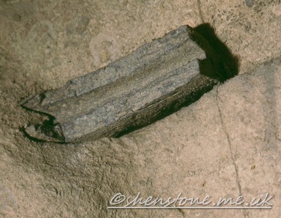
Sharks
Ctenacanthus major (shark) spine in Ogof Draenen with blood vessel hole in the bone
Most of the Fossils mentioned so far were gentle bottom dwelling filter feeders, or at least hard
shelled creatures. These are the most common, because it is these types of animals that are the
most likely to become fossilized.
Ctenacanthus major (shark) spine in Ogof Draenen
However in some places the remains of more active and more aggressive creatures can be found. In
Ogof Draenen for instance Shark teeth and fin supporting and defensive spines can be seen. These
are so common and so spectacular that they can be used to identify the particular layer of limestone
that they occur in and map it around the cave.
Some of these fins from a fish called Ctenacanthus major are so large (about 3" across) that we
can even see the holes where the blood vessels passed through the bone.
A Mineral is defined in the text books as "a substance of fixed chemical composition and structure formed by the inorganic processes
of nature."
Normally each speleothem is made from only one mineral, but some are made up from more. Each mineral has a unique chemical
composition and structure which means that it will have certain properties which can be used to identify it. To test these properties geologists use
a number of methods which include scratching the mineral or treating it with acid. Cavers should learn to rely on appearance and try and avoid
resorting to these tests.
This page covers a number of minerals that are of interest to British Cavers, some being "Cave Minerals", and some being those found
in British mine workings that are commonly visited by cavers.
In addition there is some discussion of various "biominerals" being those mineral like substances formed by the biological processes
of nature.
Limestone Minerals
Calcite - CaCO3
Calcite is the commonest mineral found in caves, being the main mineral of Limestone. It is dissolved by mildly acidic waters, but
re-precipitated to form the majority of stalagmites and stalagmites that decorate caves so wonderfully.
Not surprisingly, as calcite is the commonest limestone mineral it is also the commonest mineral of cave formations.
There are many forms of calcite crystals in caves. The size and shape of the crystals is extremely variable and depends on
a number of factors that effect their speed of formation
An excellent example of this can be seen in "Poached Egg Passage" in Giant's hole in Derbyshire. The Poached eggs are "proto
stalagmites". The inner region is frequently wet and in this region the crystals grow relatively slowly, whereas the outer edges dry out more often
and as a result the crystals in this region tend to be smaller. These latter micro crystalline areas are more opaque and this gives the poached
egg appearance
Calcite can appear as white or colourless crystals when pure, but many speleothems are coloured by iron and mud into a range of
red/brown colours and some such as the Blue Greenies behind Leonie Jayne's Playpens in Daren Cilau are coloured pale green by copper.
Dolomite - CaMg(CO3)2
Dolomite is found in different amounts in many of the limestones of the British caving regions. In
South Wales it is notable because layers that are highly dolomitised forms smaller sharper passages
Formations
Aragonite - CaCO3
Aragonite is a polymorph of calcium carbonate, that is they have the same chemical composition, but different crystal
structures (i.e.. their atoms are arranged differently). The most stable form at cave temperatures and pressures is calcite and so there are many
questions as to why aragonite should form at all. It is thought that the presence of manganese ions and the rate of evaporation have some effect.
Aragonite was thought to be restricted to the Mendip caving region, but has now been found to be widely distributed in the
Llangattwg caves
Gypsum (Selenite) CaSO4
Gypsum is often found growing from mud deposits and can form fine needles that stick up for a foot or more (30 cm to the none
imperial amongst us). Outside of caves it can be found as Massive or Desert Rose forms
Moonmilch
Moonmilk is a speleothem consisting primarly of calcite, but may also contain hydrocalcite, hydromagnesite or huntite.
Typically it looks like other dripstones, but it is soft and spongy It is formed by the deposition of calcite and other minerals from the
dripping water, but unlike other speleothems its crystals are loosely connected rods. becaquse of this it is soft and easily damaged and great
care should be taken to try to avoid walking on it
"Vein" Minerals
Galena - PbS
Galena is the primary lead ore that was sought in Derbyshire and elsewhere where Lead mining has taken place. It is an unmistakable
heavy grey mineral that breaks with cubic habit and is shiny when fresh.
Galena is one of the last minerals to be deposited in the veins and is generally found in the center of the veins surrounded by
various gangue minerals
Fluorite (Fluorspar) -CaF2
Baryte (Barytes) - BaSO4
This heavy mineral is not as heavy as galena, but then it's not metallic and shiny either. The best way of identifying barite is that
it seems like "heavy calcite". This is not strictly correct in many scientific ways, but it's a good rule of thumb.
Barite can be pinkish or white in colour and is not transparent.
Malachite - Cu2CO3(OH)2
Malachite can also form speleothems in deep, underground spaces, where the water table and hydrothermal fluids provide the means for
chemical precipitation at a much hotter temperature than normal cave developments
Azurite - Cu3(CO3)2(OH)2
Mud Minerals
Clay mineralogy is a subject for the specialists. There are many varied clay minerals and you need specialist equipment to identify
them. To the rest of us this remains a wonderfully slimy or heavy and sticky substance that we have to deal with on a routine basis.
These descriptions are not exhaustive, they provide some information on how the geology of the
areas relates to the caves. If you need more detailed information on any of these areas a good
starting point is the
Caving Regions of the UK and Eire section
of the
UK caving.com wiki
South Wales
The south Wales caving region is the British caving region that has seen the largest amount of cave discoveries in the last 20 years.
The 1960's to 1980's being the Llangattwg years with the discovery and exploration of Agen Allwedd, Ogof
Craig a Fynnon, and Ogof Daren Cilau respectively and the 1990's being now the Draenen years.
The South Wales caving region is bounded on it's inner edge by the South Wales Coalfield and on
it's outer edges by a series of mainly Devonian aged rocks above which sits the basal conglomerate.
It was been described by the late Bill Gascoigne (an excellent hydrolost based in South Wales) as a
"bowl of limestone in which the coal" sits. The bowl is not a regular shape though being a
somewhat distorted oval shape as it has suffered somewhat over geological time, being cracked
through by a series of faults that have often been eroded to give large valleys cutting into the interior.
These Valleys allow a longer and deeper section through the limestones, and are the areas where a
lot of cave exploration has focused. It is only in more recent years as extensive dye tracing work
has been carried out that the water flows through some of the more inaccessible areas have been
determined and now the caves that support these flows are being discovered.
The shallow dipping limestone with run-off from higher rock layers and the relatively deeply
incised valleys means that water can move a long way in South Wales from the point it goes
underground to the point it comes out again. Given this it is not unsurprising that South Wales has 4
of the top 5 longest caves in the UK with the following published lengths as of November 2010
according to the UK caves Database website which maintains a close eye on such things
Ogof Draenen
70km Long,
Vertical Range 151m
South Wales
Lancaster - Easegill - Pippikin - Lost
John's
60km Long
Vertical Range 211m
Yorkshire
Ogof Ffynnon Ddu
50km Long
Vertical Range 308
South Wales
Agen Allwedd
32.5km Long
Vertical Range 160
South Wales
Ogof Daren Cilau System
28km Long
Vertical Range 232m
South Wales
Derbyshire
The Derbyshire caving region is a tale of water and heat as well as the limestone. Cracked through
by a series of faults it has been flushed through by heated mineral rich waters that have left
immense mineral deposits as the waters cooled and their ability to carry strange mineral salts was diminished.
Derbyshire is an area where caves have been created, filled in again by these mineral rich
waters leaving behind their deposits, and being rediscovered as the minerals were removed by "The Old Man".
A number of Derbyshire caves have only been discovered because of the mining activity and
conversely some of the old mines of the area have only been rediscovered because of the activities of modern cavers.
Yorkshire Dales
Yorkshire is the largest UK Caving region and because of that it is also in many ways the most
diverse. Carboniferous Limestone covers (or underlies) many square miles and so there is immense potential for cave development.
The scenery of the Yorkshire dales is one that has been shaped by the rocks and by Ice. The
amount of ice covering the area at times was immense. Even the famous Three Peaks which stuck out of the ice as probably harsh bare rock at
times were sometimes covered.
It is the former presence of these Ice sheets that gives us the spectacular areas of limestone pavement that dominate the landscape
places like Chapel le Dale.
The Yorkshire Dales are characterized by beds of almost horizontal rock. The main Cave bearing rock
is the 200 m thick Great Scar Limestones overlain by shales and sandstones with thin limestones
within. These layers above the Great Scar Limestone are the Yoredales, formed in shallower
waters. The thin limestones of the Yoredales do contain some caves, e.g. Nettle Pot in Dentdale.
but are most important because the boundary between these rocks and the thicker limestone
below is the first chance that water has to sink rapidly through the limestone and is therefore the
site where many of the caves start.
Mendip
Mendip is a fairly complex piece of limestone geologically speaking. The rocks are more strongly
folded than in other "major" caving regions. This gives the caves an unusual character of steeply dipping passages and deep sumps.
Ireland
County Clare has to be one of the most stunning places in the British Isles to go caving - even if
you never go underground. The magnificent expanses of carboniferous limestone pavement and the
friendly and warm reception that you get wherever you go means that this is a personal favorite for just a break.
The caves tend to be small, but there are a number of systems that do link, but only for the
divers. This can be explained by the relatively flat bedding and low relief that means that the water table is fairly close to the surface
The "Minor" Caving Regions
Dudley
There is and unexpected and little visited area of speleological interest in the West Midlands can
be found in the area of the Wrens Nest Nature Reserve. The Place to visit is the Mines that are in the Silurian (Wenlock) Limestone.
The mines have been mined in pillar and Stall fashion, but are quite extensive. There is a significant depth to these systems
in places, but the lower levels are flooded and are accessible only to divers.
The site is a well-preserved Silurian coral reef with more than 700 types of fossil which have been
discovered there. Probably the most famous (especially locally is Calymene blumenbachi,
a trilobite nicknamed the Dudley Bug or Dudley Locust by 18th century quarrymen. For a geologist
it is a wonderful place to visit as you can see a real reef ecosystem of corals, tabulate &
Rugose, sponges, bryozoans, brachiopods, gastropods, bivalves, crinoids, criconarids, nautiloids, etc.
When quarrying finished in the early 20Th century, the site was left with a substantial network of underground caverns many of which
are now flooded to a considerable depth. The site was originally studied by the Sir Roderick Murchison,
whose work in defining the Silurian System was mainly based on fossils and rock formations found at sites in Dudley.
The Wren’s Nest is such an important paleontological site, that in 1956 it became a National Nature Reserve (NNR).
Wren’s Nest was actually Britain’s first geological NNR.
In October 2004, Wren’s Nest and Castle Hill were declared a Scheduled Ancient Monument in
recognition of them having the best surviving remains of the limestone quarrying, mining and processing industry in Dudley. This includes the
last remaining surface opening limestone cavern in the world – known as the Seven Sisters. There was
a major roof collapse in October 2001, which, if left unchecked, could have resulted in the loss of the Seven Sisters so there have been programmes
to look at stabilization work. They are also looking to increase the tourism capability of the site which is probably not good for wild caving,
but if it preserves the site it's got to be worth it.
Devon
Devon has some interesting if small caves and some interesting mines. Some of the latter are to
be found near the wonderful village of Beer in East Devon where the Beer Quarry caves complex is open to the public.
Yorkshire Moors
Although the Yorkshire dales is the classic British caving region, there are caves to be found on the moors and the East coast.
North Wales
North Wales has a number of Carboniferous limestone outcrops in the area around the Great
Orme and continuing down past Ruthin and down to Oswestry. Classic sites include the Minerva Mine Complex and the Great Orme Mines themselves.
There is a decent amount of limestone here (about 400m on the Great Orme), but it has been subjected to dolomitization and
mineralization.
The Great Orme mines are famous as copper mines, but also include some earlier emplacement of Lead and zinc minerals.
Skye/Scotland
The caves of Skye are small and sharp, having been formed in very old and marbleized Durness limestone.
The limestones have been marbleized by the emplacement of the tertiary volcanics (the rocks of the Red and Black Cullins which were
emplaced as molten rocks). They include dykes of igneous rocks in places (although I'm not sure if this has been seen in any caves).
have every intention of adding some information about natures other underground environment, Lava Tubes which I also enjoy
exploring when get some time in the mean time please take a look at some of my
Lava tube pictures from Tenerife
and the information page accompanying those pictures
and this excellent page from the NSS Lava Tubes
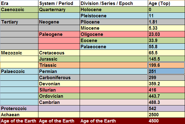
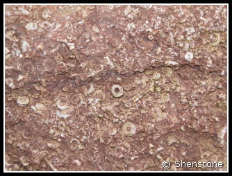
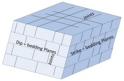
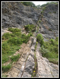
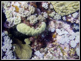
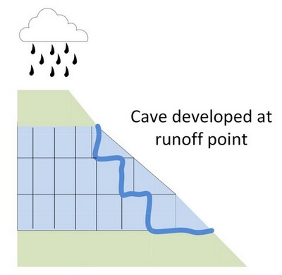
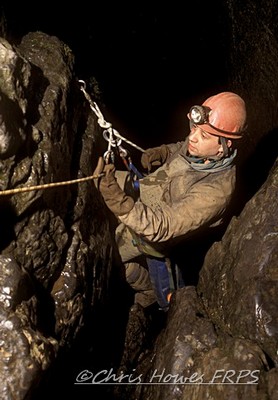
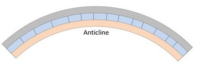
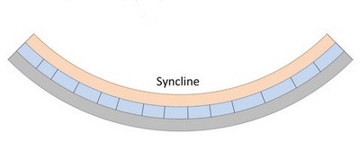
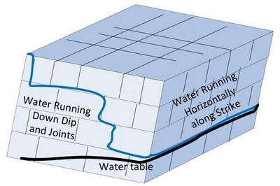
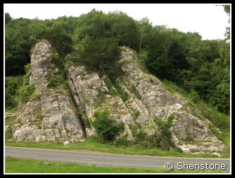
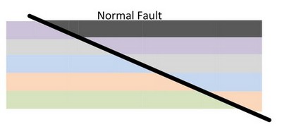
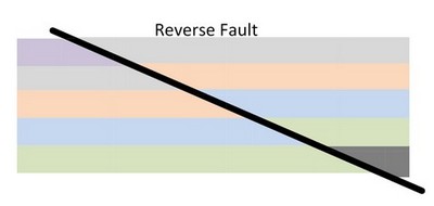
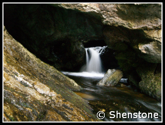
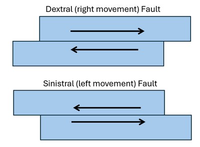
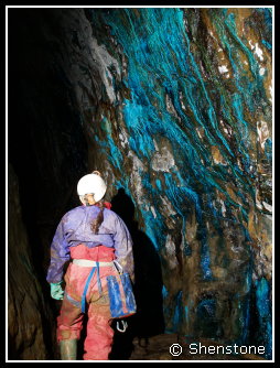
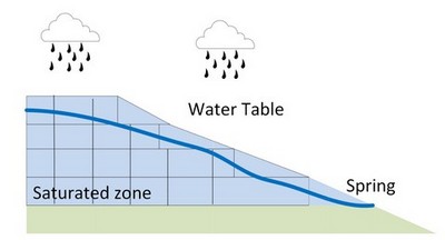

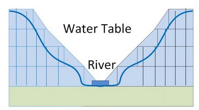
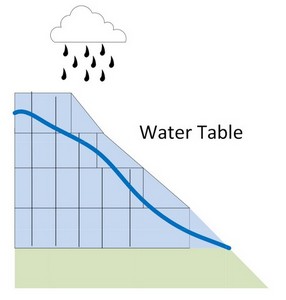
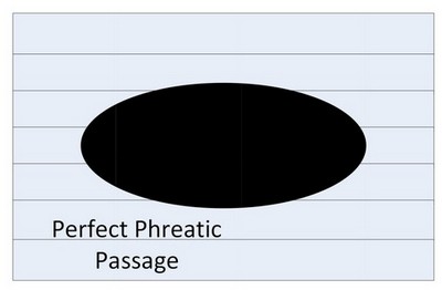
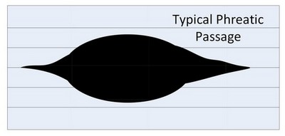
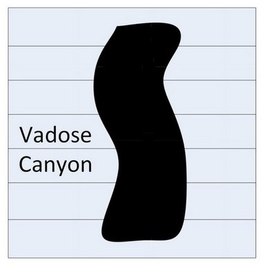
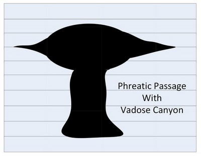
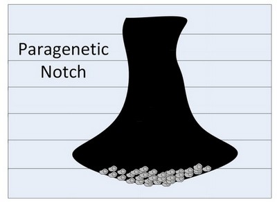
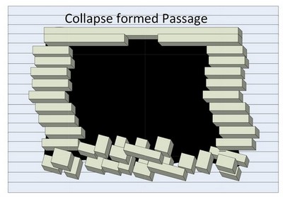
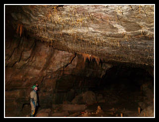
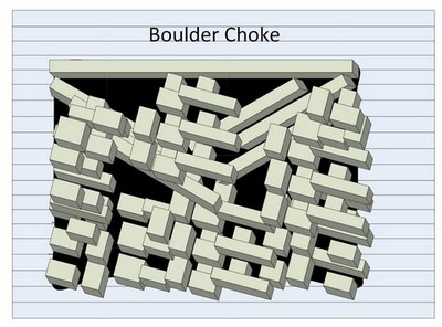
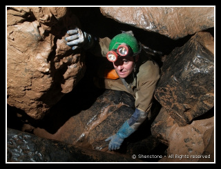
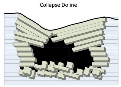

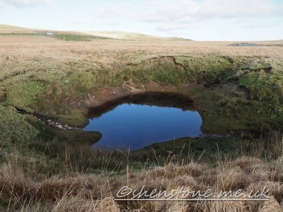
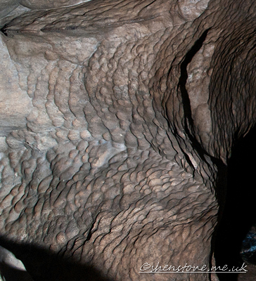
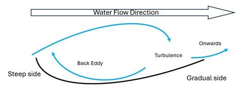
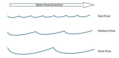
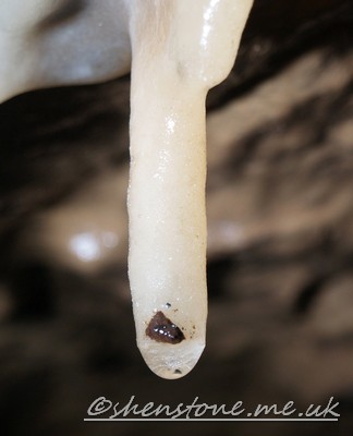
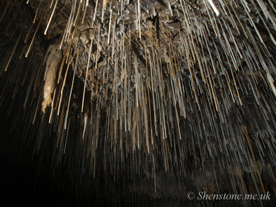
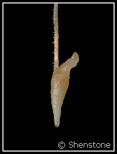
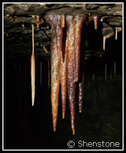
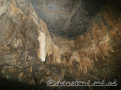
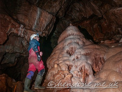
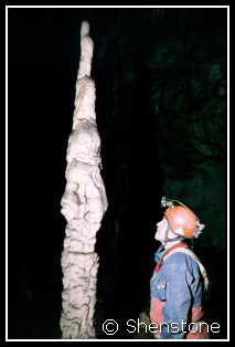
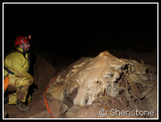
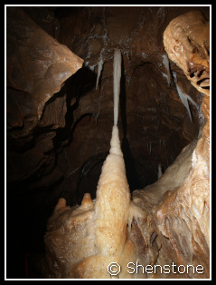
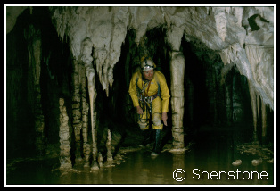 Columns are formations that reach from floor to
ceiling, they are normally formed when a stalactite and stalagmite reach each other and coalesce.
Columns are formations that reach from floor to
ceiling, they are normally formed when a stalactite and stalagmite reach each other and coalesce. 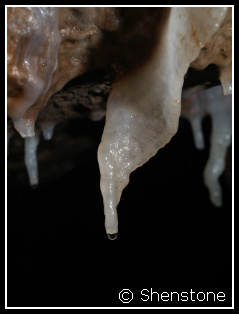
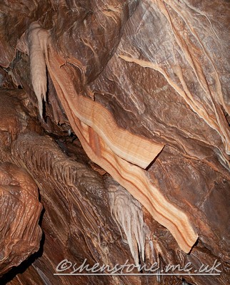
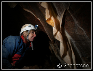
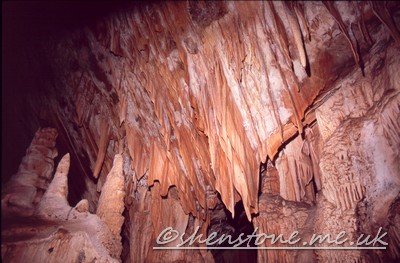
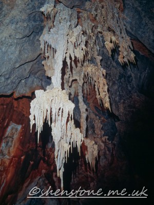
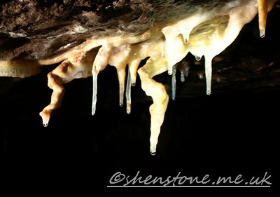
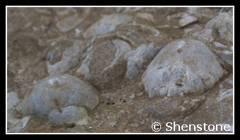
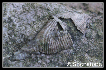
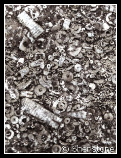 Another fossil that is at least as common in limestone as the brachiopods
is the Crinoid or "sea lily". These fossils often go unnoticed because they are usually fragmented into unspectacular pieces. This is a shame
as the complete animal is quite spectacular.
Another fossil that is at least as common in limestone as the brachiopods
is the Crinoid or "sea lily". These fossils often go unnoticed because they are usually fragmented into unspectacular pieces. This is a shame
as the complete animal is quite spectacular.